Well Properties: Tops Tab
The Tops tab displays information about the formation well tops for the
selected
well.
-
Select a well from the Wells list.
-
Scroll to the last line of the tops table. It should be blank.
-
Select a Formation by left clicking on the arrow in the Formation column. If the formation doesn't appear in the list you will have to add it from the Formations tab.
-
Enter a Depth. Make sure that you are using the correct depth reference and units.
-
Select a Type by left clicking on the arrow in the Type column.
-
Select an Owner. Note: You will only be able to alter the owner if you have adequate permissions.
-
Select a Source by left clicking on the arrow in the Source column. If the source doesn't appear in the list you can type it in, and it will be added to the database.
-
Click
 .
The top
will now be associate with the UWI.
.
The top
will now be associate with the UWI.
General Information
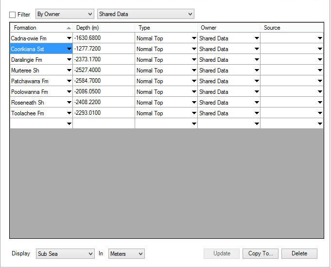
Tops Table Columns
Formation: Lists the formation ID for the top. You add these on the Formations page.
Depth: Displays the depth of the top. The units are determined by the Display parameters.
Type:
Displays the type of the top. The top types are as follows:
Normal Top: These are traditional tops defined as positions along the well bore.
Generic Depth: These are "pseudo" top values that include a unit of measurement (meters or feet). They are not referenced to the depth datum of the well. They might be created as a result of a well calculation that defines the stratigraphic thickness of a formation.
Unitless Value: These are "pseudo" top values that do not include a unit of measurement. They are not referenced to the depth datum of the well. Defining tops that are unitless values allows you to post any type of arbitrary data on the map.
Owner:The owner of the top. You may own a top without owning a well.
Source:
Displays the (optional) source for a top. Using
sources can
help
manage tops from different users.
Tops Table Filtering
Filtering the tops list may make it easier to find the tops information
you're interested in.
Filter:
When checked on, this item allows you to view tops
from a single source or owner. Once active, select By Owner or By Source and then select the
specific value you want to use as your filter from the second drop down
menu.
Tops Table Display Options
Changing the display options lets you change how the depths are
displayed in the table.
Display: Set how to display the well top values.
Depth
Type: Select depth reference for display.
Subsea: Display depths as subsea.
TVD: Display depths as true vertical depth.
Measured Depth: Display depths as measured depth.
Depth Units: Select depth units for display.
Meters: Display tops in meters regardless of how they are stored in the database.
Feet: Display tops in feet regardless of how they are stored in the database.
Note: MD =
KB - SS. For
vertical wells, MD = TVD, but for deviated wells the correction will be
made based on the loaded survey.
Tops Operations
Update:Save
any modifications deletions or additions to the tops.
 Copy To: Copy
tops to one or
more wells
using Copy Tops to Wells dialog. You
need to select the tops from the table before pressing this button.
Copy To: Copy
tops to one or
more wells
using Copy Tops to Wells dialog. You
need to select the tops from the table before pressing this button.
 Delete:
Delete the selected tops from the list. The tops will
not get
deleted from the database until you click .
Delete:
Delete the selected tops from the list. The tops will
not get
deleted from the database until you click .
Well Properties Tabs
- Well Tab
- Tops Tab
- Formations Tab
- Sources Tab
- Velocity Curves Tab
- Log Curves Tab
- Synthetics Tab
- Directional Surveys Tab
- Raster Logs Tab
- Production Entity Tab
- Production Volumes Tab
- Advanced Tops Tab
- Advanced Velocities Tab
- Advanced Logs Tab
- Advanced Synthetics Tab
- Advanced Production Tab
— MORE INFORMATION

|
Copyright © 2020 | SeisWare International Inc. | All rights reserved |