Seismic Zone Attributes
The Seismic Zone Attributes application allows you to specify a
window of data over which an attribute is computed. There are various attributes
that can be computed.
The output from the calculation can be displayed as a
horizon
on the Basemap.
 How do I calculate a seismic zone attribute?
-
Select the Seismic Lines that you will perform the analysis on. You can select them from the list by clicking on them (hold Ctrl down to select multiple lines) or by selecting an area on the Basemap.
-
Enter a Base Output Name. The results on the map are named "Base Output Name SUFFIX" where the suffix is any of the abbreviations listed in brackets next to the attribute type.
-
Select the Attributes to be run. Note: you can run any number of attributes at the same time.
-
Define the Windowing Method. This defines the zone over which the analysis is performed.
-
(Optional) If calculating Correlation Coefficient or Manhattan Distance, click
 .
. -
(Optional) Specify polygons.
-
Click
 to generate
results. Note:
Horizons are only visible on the Basemap and will not show up in your
Seismic Viewer.
to generate
results. Note:
Horizons are only visible on the Basemap and will not show up in your
Seismic Viewer. -
(Optional) Click
 to save
your
current
configuration .
to save
your
current
configuration .
General Information
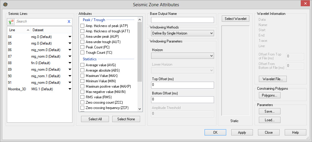
Seismic
Lines
Select the lines you want to use in your Seismic Zone Attributes analysis. The working set version is listed, but alternate datasets can be selected by clicking on the down arrow in the Dataset cell. Left click to select a seismic line, or use the Ctrl key on your keyboard to select multiple seismic lines. Alternately, select a group of lines from the Basemap.
To to help you make your line selections, you can sort any
column
by left clicking
on the column header, you can apply a filter
( ), or
you can type a search string
into the search
bar to limit the list using Line,
and Dataset
information.
), or
you can type a search string
into the search
bar to limit the list using Line,
and Dataset
information.
For additional selection and navigation options right click on the Seismic Lines list
to access
the shortcut
menu.
Attributes
Select from the list of Attributes.
Remember when running Correlation
Coefficient (CC) and Manhattan Distance (MHD) calculations you will
also need to select
a wavelet.
 Select All:
Select all of
the attributes in the list. You can then remove check marks from any
unwanted attributes.
Select All:
Select all of
the attributes in the list. You can then remove check marks from any
unwanted attributes.
 Select None:
Remove the check
mark from all of the selected attributes to re-start your attribute
selections.
Select None:
Remove the check
mark from all of the selected attributes to re-start your attribute
selections.
Base Output Name
Base Output Name: Enter a base name here. Each attribute will be computed and stored in a horizon that uses the base name with the appropriate extension added. For example, if the base name is "SeisWare", the area under peak will be stored into a horizon called "SeisWare AUP". You'll notice that the extension added is shown in the dialog in parenthesis. Note: if you load a saved set of parameters the Base Output Name box will be populated.
Windowing Method and Windowing Parameters
Select a windowing method to determine the range of data that will be
used in the attribute analysis. Note:
Offset
values can be positive or negative. The value is added to the reference
so a negative time will move above and a positive value will move below
the reference.
Windowing Methods: Select
a windowing method.
- Define By Single Horizon: Use a single horizon with offsets.
- Define Using Vertical Range: Use a vertical range with offsets.
- Define Between Horizons: Use two horizons with offsets.
- Define Between Horizons and Datum: Use a horizon with an offset, and a datum.
Amplitude Threshold:This only applies for the Amplitude Thickness and Area Under attributes. It is an amplitude valued defining a threshold above or below which the attribute is calculated.
Constraining Polygons
 Polygons: Open the Select
Polygons dialog to
select inclusion or exclusion polygons to define the geographical
extents of the operation.
Polygons: Open the Select
Polygons dialog to
select inclusion or exclusion polygons to define the geographical
extents of the operation.
Select Wavelet
Select
Wavelet:
After clicking this button, click on a
seismic trace in any Seismic Viewer or a trace location on the Basemap.
This will specify the trace to be used in the Correlation Coefficient
(CC) and Manhattan Distance (MHD) calculations. For other
attributes, this can be used to view the data in the zone specified for
the attribute calculation.
Wavelet Information
The Wavelet Information will populate after a wavelet file has been selected.
 Wavelet File:Open a wavelet file
that has been saved in the Seismic Viewer to be used in the Correlation
Coefficient (CC) and Manhattan Distance (MHD) calculations.
Wavelet File:Open a wavelet file
that has been saved in the Seismic Viewer to be used in the Correlation
Coefficient (CC) and Manhattan Distance (MHD) calculations.
Parameters
Save: Save
the current
configuration to an XML file on your hard drive.
 Load:
Find a previously
saved XML configuration file and load all settings from it.
Load:
Find a previously
saved XML configuration file and load all settings from it.
— MORE INFORMATION

|
Copyright © 2020 | SeisWare International Inc. | All rights reserved |