Convert Columnar ASCII File
This page allows the user to perform coordinate conversions on a columnar ASCII file.
-
Click
 to select the source Coordinate System.
 -
Click
to select the Input File for coordinate
conversion. -
Click
 to define which
columns will be converted. You need to define
either the X and Y columns or the latitude and longitude columns. If
you define X and Y as well as latitude and longitude both sets of
columns will be converted. For help with this step refer to the defining columns help
document.
to define which
columns will be converted. You need to define
either the X and Y columns or the latitude and longitude columns. If
you define X and Y as well as latitude and longitude both sets of
columns will be converted. For help with this step refer to the defining columns help
document. -
Click
to select the destination Coordinate System. -
Specify an output file name. Click
to specify an output directory for the Output File. -
Select your Output Options. Note: You can convert a file from degrees minutes seconds to decimal degrees in this section.
-
Click
 .
.
General Information
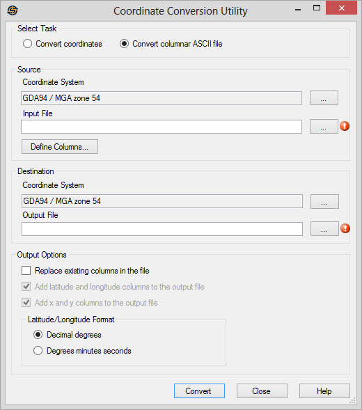 Source
Specify information about the source file to convert.
Coordinate
System: This is the coordinate system associated with the data
in the input
file. Select or define the coordinate system by clicking  . By default this is set to the
coordinate system in the project properties
dialog if you have a project selected. If you are not currently in a
project the coordinate system will be blank.
. By default this is set to the
coordinate system in the project properties
dialog if you have a project selected. If you are not currently in a
project the coordinate system will be blank.
Input
File: This is the columnar ASCII file
that you will be
performing conversions on. You can click and select the file, or type the
name into the dialog.
Define Columns:
Click on this
button to define the columns from the file for conversion. You need to
define either the X and Y columns or the Latitude and Longitude
columns. If you define X and Y as well as Latitude and Longitude both
sets of columns will be converted. For help with this step refer to the
defining columns help
document. Note: You can specify columns
other than X, Y, Latitude and Longitude. Any extra columns specified
will be written to the output file unmodified.
Destination
Specify information about the file to output after the coordinate
conversion.
Coordinate
System:This is the coordinate system that the data will
be converted to before
being written to the output file. Select or define the coordinate
system by clicking on . By default this is set to
the
coordinate system in the project
properties dialog if you have a project selected. If you are not
currently in a project the coordinate system will be blank. Note: Set the destination coordinate system to be
the same as the source coordinate system if you are just creating x and
y locations from latitude and longitude values, or if you are just
creating latitude and longitude values from x and y locations.
Output File:
This is the columnar ASCII file that will contain
the converted data after performing coordinate conversions on the Input
File. You can click and select the file, or type the
name
into the dialog. Note: If the input file is
fixed width, the output file will be written as a tab separated
columnar file. Also note that any comments that may appear in the input
file will be lost.
Output Options
Specify addition information about how to format the output file.
Coordinate
System:This is the destination coordinate system when
converting between two
coordinate systems. If you only want to convert latitude and longitude
values to x and y values you do not need to define this coordinate
system. Select or define the coordinate system by clicking . By default this is set to the
coordinate system in the project
properties dialog if you have a project select. If you are not
currently in a project the coordinate system will be blank.
Replace existing columns in the file: Checking this option will allow you to convert the X, Y, Latitude and Longitude columns in place within the file. The converted values will appear in the same columnar location in the output file.
Add latitude and longitude columns to the output file: Check this option to add an extra column of latitude and longitude values to the output file. The original latitude and longitude values will appear in the output file along with the converted values. Note: This option is not available when Replace existing columns in the file has been selected.
Add x and y columns to the output file: Check this option to add an extra column of x and y values to the output file. The original x and y values will appear in the output file along with the converted values. Note: This option is not available when Replace existing columns in the file has been selected.
Latitude/Longitude
Format: Specify how you would like the
latitude and longitude values to appear
in the output file. Note: You can convert a
file from degrees minutes seconds to decimal degrees by changing this
option.
-
Decimal degrees: Output latitude and longitude values in decimal degrees. (e.g. -54.3923491)
-
Degrees minutes seconds: Output latitude and longitude values as degrees, minutes and seconds (e.g. 54 23 32.4567235 W)
Convert
Convert: Convert
the input file and write the result to the output file.
Also See
— MORE INFORMATION

|
Copyright © 2020 | SeisWare International Inc. | All rights reserved |