Well Properties: Raster Logs Tab
The Raster Logs page contains a list of raster logs associated with the selected well. Select a log from the list to view and edit the properties for the log, or delete the raster log from the project. Raster logs are also included in the list curves on the Log Curves tab.
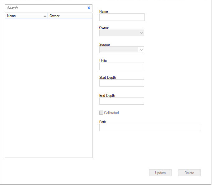
Raster Logs List
This displays list of raster logs associated with the selected well.
Select a raster log to view or edit the parameters for the log. Type
a search string into the search bar
to limit the
information in the list.
Owner: The owner of the raster log.
Raster Log Parameters
Select a raster log from the table to view or edit the parameters for
that log.
Name: The name of the currently selected raster log.
Owner:The owner of the currently selected raster log.
Source: The source of the raster log. Sources can be used to manage data from different users.
Units: Units for the currently selected raster log.
Start Depth: The start depth for the currently selected raster log. This is for your information and can't be edited.
End Depth: The end depth for the currently selected raster log. This is for your information and can't be edited.
Calibrated: This indicates that the raster log has been calibrated.
Path: The file location of the raster image file. This is for your information and can't be edited.
Raster Log Operations
 Update:Write
any modifications
made to the currently
selected raster log to
the
database.
Update:Write
any modifications
made to the currently
selected raster log to
the
database.
 Delete: Delete the
currently
selected raster logs
from the database.
Delete: Delete the
currently
selected raster logs
from the database.
Well Properties Tabs
- Well Tab
- Tops Tab
- Formations Tab
- Sources Tab
- Velocity Curves Tab
- Log Curves Tab
- Synthetics Tab
- Directional Surveys Tab
- Raster Logs Tab
- Production Entity Tab
- Production Volumes Tab
- Advanced Tops Tab
- Advanced Velocities Tab
- Advanced Logs Tab
- Advanced Synthetics Tab
- Advanced Production Tab
— MORE INFORMATION

|
Copyright © 2020 | SeisWare International Inc. | All rights reserved |