Well Import: Import Raster Files
The Import Raster Log page of the Well Import wizard is used to identify the image file associated with the calibrated raster log file, and to associate the raster log with an existing well in the project. This page is only available when you are importing a raster log using a *.lic or *.xml format calibration file.
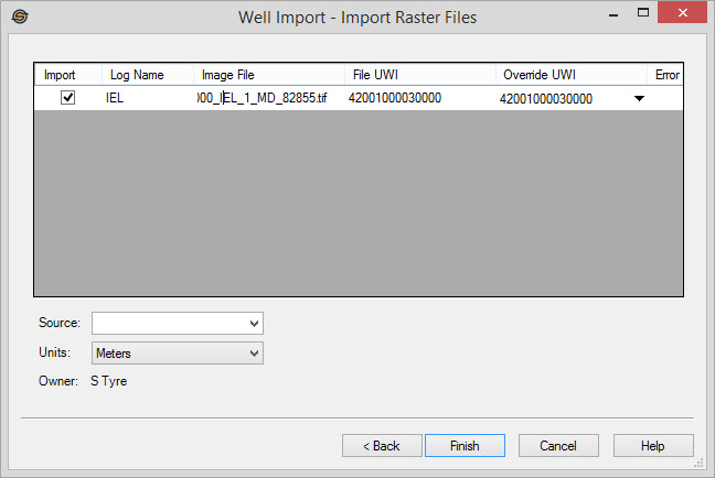
Raster File Table
Import: A check mark indicates that no errors were found with the information associated with the raster log, and that the image will be imported. If any errors are encountered, the check mark will automatically be removed.
Log Name: The name of the raster log. This is extracted from the file, but can be edited.
Image File: The file path to the image file associated with the file, assumed to be in the same folder as the calibration file. Click  to map to a different file location.
File UWI: The UWI extracted from the file. This is for information only, and can't be edited.
Override UWI: Select the UWI of the well you want associated with the raster log you are importing. If the File UWI matches an existing UWI in the project, this field is automatically populated.
Error: If there is an error found with the information associated with the raster log, an error symbol will appear in this column (![]() ). Place your cursor over the error symbol for details.
). Place your cursor over the error symbol for details.
Additional Parameters
Source: Optionally specify the source you want associated with the raster log.
Units: Specify the units referenced in the calibration file, Meters or Feet.
Owner: The owner that will be associated with the imported raster log. This is for your information and can't be edited. To change this field, you need to impersonate the correct owner.
Well Import Options
— MORE INFORMATION

|
Copyright © 2020 | SeisWare International Inc. | All rights reserved |