Well Import: Specify Data
The Specify Data page of the Well Import wizard allows you to identify the types of data you are importing. Note that not all data types are available for all file formats, and some options may appear grayed out. Other options may be available, but you may not be able to select multiple data types in one operation.
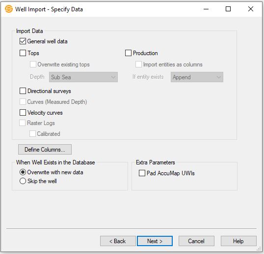
Import Data
Select the types of data to import. Data will only be imported if the data type it belongs to is selected on this page. Note that not all data types are available for all file formats.
General well
data: Import general well data including UWI, location
and status.
Tops: Import well top information.
Overwrite existing tops: Turn this on to overwrite well tops that already exist in the database where the name and source match the tops in the file. Turning this item off will allow you to import multiple tops with the same formation name for a given well.
Depth: Select the format of the depth values for the input tops. This is only used when importing columnar data. Note: When importing curves from LAS files they are always assumed to be measured depth.
- Subsea: Tops in the file represent subsea values.
- Measured Depth: Tops in the file are in measured depth.
- TVD: Tops in the file are in true vertical depth.
- Generic Depth: Tops in the file represent depth values (i.e. they have depth units) but are not referenced against the datum elevation for display purposes.
- Unitless Value: Tops in the file represent generic values that have no depth units. This type is often used to post arbitrary values on the map.
Production Data: Import production data.
Import entities as columns: Turn this on when the entities in the columnar ASCII production file appear as column headings. When this is turned on, you will also be required to map the entity names on the Production Import Parameters page of the Well Import wizard. Note: In addition to the entity name, the column header must also contain a fluid identifier.
If entity exists: Specify the overwrite behavior when a production entity already exists in the database.
- Append: If an entity exists in the database, add additional information from the file to the database, but don't alter existing data. This will commonly be used when you are adding new monthly production data, but don't want to alter existing records.
- Overwrite: If an entity exists in the database, replace any existing information with information found in the file. Any information that exists in the database but not in the file will remain unchanged.
- Skip: If an entity exists in the database, skip the well and do not add any additional information.
Curves (Measured Depth): Import well curves. Note: SeisWare assumes all curves are in measured depth.
Velocity curves: Import velocity curves from the file. Velocity curves are sometimes referred to as TD curves.
Directional surveys: Import directional survey data.
Raster Logs: This options is automatically selected when you are importing calibrated raster logs in *.lic or *.xml format. You will proceed to the Import Raster Files page of the wizard.
Calibrated: Indicates that the raster logs have been calibrated.
Well Zone Types: This option is only available if importing an IHS 297 file. The zone types available to import for this option are Cores, DST's, IP's, and PDT's.
Define Columns
This button only appears when you are importing columnar data.
 Define
Columns: Open the Define
Columns
dialog. Column definitions differ
depending on the type of data being imported.
Define
Columns: Open the Define
Columns
dialog. Column definitions differ
depending on the type of data being imported.
When Well Exists in the Database
This specifies how wells that are already loaded into your SeisWare project should be dealt with.
Overwrite with new data: Select this item to overwrite any data in your SeisWare project with data from the input files.
Skip the well: Select this item to skip over any wells that already exist in the database. Use this item to avoid overwriting any of your modifications while allowing you to import new wells into your project.
Extra Parameters
This area specifies extra import parameters.
Pad AccuMap
UWIs: If the
original well data came from AccuMap it may only have fourteen
characters instead of the standard sixteen for the unique well
identifier. This can cause problems when merging data from
different packages. Check this item to pad the UWIs to 16
characters.
Well Import Options
— MORE INFORMATION

|
Copyright © 2020 | SeisWare International Inc. | All rights reserved |