Well Import: Coordinate Conversion
The Coordinate Conversion page of the Well Import wizard allows you to specify parameters for
coordinate
conversion.
Coordinate System Parameters
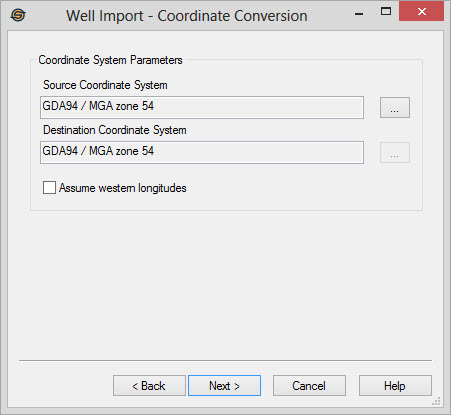
Source Coordinate System:
This is the source coordinate system of the well files you
are
importing. Select a coordinate system by clicking  . By default this is set to the
coordinate system in the
project
properties
dialog. If you have obtained input files that are based on a
different coordinate system from that of the project, set this to
automatically perform coordinate conversion.
If you do not have a coordinate system defined for the
project,
this will be blank.
. By default this is set to the
coordinate system in the
project
properties
dialog. If you have obtained input files that are based on a
different coordinate system from that of the project, set this to
automatically perform coordinate conversion.
If you do not have a coordinate system defined for the
project,
this will be blank.
Destination
Coordinate
System: This is the destination coordinate system
for the project.
Select
a coordinate system by clicking . By
default this is set to the coordinate system in the project
properties dialog. It is best to set this in the project
properties rather than in this dialog.
If you do not have a coordinate system defined for the
project,
this will be blank.
Assume western longitudesTurn this on to specify that all longitudes are in the western hemisphere. Many older Photon ASCII files will have positive longitudes for data in the western hemisphere. Turning this on ensures that values are correctly converted to map units. Turn this off if your longitudes are actually in the eastern hemisphere.
Well Import Options
— MORE INFORMATION

|
Copyright © 2020 | SeisWare International Inc. | All rights reserved |