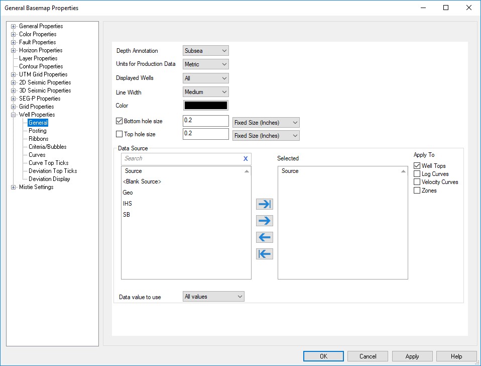
Well Properties: General
The General settings for well controls the appearance of well symbols
and the source settings that will be used for tops and curve
display.
Display Options
Depth Annotation Display well values in Subsea, MD, or TVD. You can override this for specific postings, using the Custom Well Posting option. Note: By default the depth is subsea.
Units for Production Data: Choose between Metric and Imperial for production data units.
Displayed Wells: Select which wells are visible on the Basemap. You can use filters or criteria no limit the wells being displayed. If there are no filters in this list, create one in the Data Filter Manager. If you don't have any well criteria, create one on the Criteria/Bubbles page. Note: If you select In Criteria but don't currently have any criteria selected, all of your wells will be displayed.
Line Width: Specify the thickness of the line used to draw the symbol.
Color: The default color for well symbols.
Bottom Hole Size: The toggle turns the bottom hole symbol on and off. If turned on, specify the size of the symbol. You can use criteria or bubble postings to override the appearance of select wells. Note: Fixed sized objects will remain the same regardless of the map scale. Variable sized objects will change size with the map scale.
Top Hole Size: The toggle turns the surface hole symbol on and off. If turned on, specify the size of the symbol. You can use criteria or bubble postings to override the appearance of select wells. Note: Fixed sized objects will remain the same regardless of the map scale. Variable sized objects will change size with the map scale.
Data Source List
The Available and Selected sources can be moved between lists using the selection arrows, or by double clicking on the source.
Available: A list of the sources available in the project. Sources can be sorted by clicking on the column header.
Search Bar:Type a search string into the Search Bar to limit the information in the list.
Selected: A list of the source that will be used to limit the well information being displayed. If no sources are selected, then all sources are used. <Blank Source> uses wells that were loaded without a source. See the Sources page of Well Properties for more information.
Apply To: Select the data type(s) for which you want the source selections applied.
- Well Tops: Use the selected sources to limit the well tops being displayed on the Basemap.
- Log Curves: Use the selected sources to limit the log curves being displayed on the Basemap.
- Velocity Curves: Use the selected sources to limit the velocity curves being displayed on the Basemap.
- Zones: Use the selected sources to limit the zones being displayed on the Basemap.
Data
value to use: For wells that
have
multiple values for the defined posting, specify which data value to
use.
- Any Value: The first value loaded into the database. This option ensures backwards compatibility.
Shallowest value: The shallowest value in TVD.
Deepest value: The deepest value in TVD.
All values: All values will be posted.
Sum values: The sum of all data values will be posted.
Average Values:The average of all data values will be posted.
Also See
— MORE INFORMATION

|
Copyright © 2020 | SeisWare International Inc. | All rights reserved |