Map View Tools: Select Surface for Map View
Use the Select Surface for Map View dialog box to select the surfaces to display on the map. You can also access the dialog boxes used to set the default grid and contour parameters. You can select as many surfaces as you want, and then use the surface arrows (![]() /
/![]() ) on the Actions toolbar to cycle through them. To open the Select Surface for Map View dialog box, on the Buttons toolbar click
) on the Actions toolbar to cycle through them. To open the Select Surface for Map View dialog box, on the Buttons toolbar click  .
.
Menus
There are menus at the top of the dialog box to access additional tools and options.
File Menu: Use the File menu to save your project, export grid files. ![]() See File menu options...
See File menu options...
Options Menu: Use the Options menu to set grid and contour display preferences, and add a title to the surface display. ![]() See Options menu options...
See Options menu options...
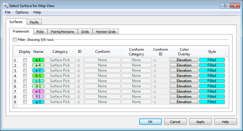
Surfaces and Faults Tabs
Use the Surfaces and Faults tabs to select the surfaces and faults you want to display on the map, and adjust their display properties. You can turn on data from any tab. Each tab contains the associated display options for each data type, as well as informational fields that can't be edited.
Column Definitions
The following is a list of definitions for the columns found of the Framework tab. Note that the other tabs will only have the columns relevant to the specific data type.
Display: Place a check mark next to each surface you want to display. Note that you can select multiple surfaces, but can only display one surface at a time.
Name: The name and color of the surface. Click on the name to open the Change Surface Color dialog box to change the color of the surface for the entire project. On every other tab, click on the name to open the Copy Surface or Change Surface Color dialog box to create a copy of the surface with a different name, or change the surface color of the surface for the entire project.
Category: The surface type. This informational column is useful on the Framework tab where multiple data types can be present.
ID: Any value other than “-1” indicates that the data was loaded from OpenWorks. This column is for information only.
Conform: The conform method used to create the surface. This column is for information only.
Conform Category: The surface type of the conform surface. This column is for information only.
ID: Any value other than “-1” indicates that the data was loaded from OpenWorks. This column is for information only.
Conform ID: Any value other than “-1” indicates that the conform surface was loaded from OpenWorks. This column is for information only.
Color Overlay: Select an overlay option to specify how to apply color to the surface in conjunction with the Style selection. ![]() See Color Overlay options
See Color Overlay options
Style: Specify how the surface should appear in the display. Choose from Filled, Filled with Contours, Contours.
— MORE INFORMATION

|
Copyright © 2020 | SeisWare International Inc. | All rights reserved |