Map View Tools: Select Isochore for Map View
The Select Isochore for Map View dialog box is used to select a top and bottom surface that will be used to create an isochore map to be displayed on the map. To open the Select Isochore for Map View dialog box, on the Buttons toolbar click  .
.
Menus
There is a series of menus at the top of the dialog box to help you access additional tools.
File Menu: The File menus allows you to export or save your isochore grid or the point sets used to create the grid. ![]() See File Menu Options...
See File Menu Options...
Options Menu: The Options menu is used to specify how the isochore and isochore grid will be generated, and turn on a title and markers for the isochore. ![]() See Options menu options...
See Options menu options...
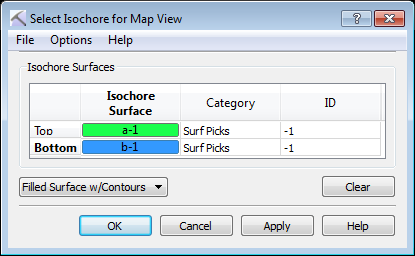
Isochore Surfaces
Select the top and bottom surface, and determine how the isochore will be displayed.
Top: Open the Choose One Surface dialog box to select the upper isochore surface.
Bottom: Open the Choose One Surface dialog box to select the lower isochore surface. This will be subtracted from the Top surface.
Display Options: Select a display option. Choose from Filled Surface with Contours, Filled Surface, or Contours.
![]() Clear: Open the Choose One Surface dialog box to select the upper isochore surface.
Clear: Open the Choose One Surface dialog box to select the upper isochore surface.
— MORE INFORMATION

|
Copyright © 2020 | SeisWare International Inc. | All rights reserved |