Map View Tools: Select Isochore Parameters
The Select Isochore Parameters dialog box is used to determine how the isochore will be generated, using data from the well points only, or data from structural grids.
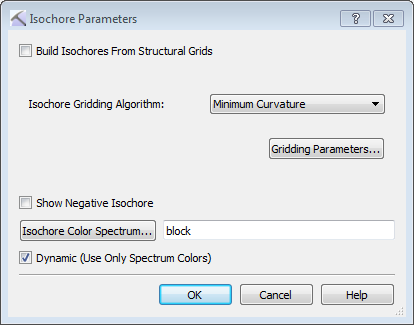
Build Isochores from Structural Grids: Specify how the isochore grid should be calculated.
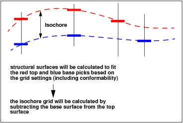
On: Isochore values are calculated by subtracting the Bottom Isochore Surfacefrom the Top Isochore Surface. Isochore values will be calculated in the areas where both the Top and Bottom surfaces are present. This is the default setting.
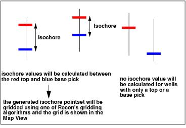
Off: Isochore values are calculated for wells where the Top and Bottom Isochore Surfaces are present. The resulting point set is gridded and displayed on the map. When you choose this option you are required to pick the Isochore Gridding Algorithm and set the Gridding Parameters. This is the setting required if you want to display isochore data points on the map.
Isochore Gridding Algorithm: Select a gridding algorithm. Choose from Minimum Curvature, Radial Search, Radial (Clustered), or Weighted.
 Gridding Parameters: Open the Set Gridding Parameters dialog box to adjust the gridding parameters used to create the isochore grid.
Show Negative Isochore: Turn this on to allow negative isochores if the Top and Bottom Isochore Surfaces cross each other. When this is turned off, negative values are ignored and the isochore grid will stop at the zero contour.
 Isochore Color Spectrum: Open the Color Spectrum Manager to select a colorbar for the isochore.
Dynamic (Only use spectrum colors): Turn this on to apply the spectrum across the range of data present in the isochore, not the range of data associated with the spectrum.
— MORE INFORMATION

|
Copyright © 2020 | SeisWare International Inc. | All rights reserved |