Grid and Contour: Contour Extents
The Contour Extents page allows you to specify the name extension for the contour layer and compute the minimum and maximum Z values for the generated contours.
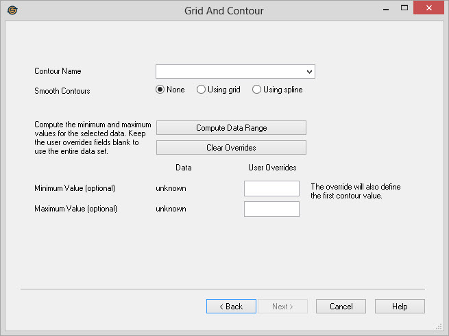
Contour Name
Name Extension: If gridding seismic interpretation
data, the contour name that selected
will be added after the horizon name. If gridding well tops, the
contour name that is selected will be added after the formation name.
If creating a grid with contours, the gridding extension will
automatically be used.
Contour Smoothing Parameters
Smooth Contour: You have the option to smooth a
contour using a spline or using a grid
method. When using a grid to smooth the line, the original grid is
resized to 5 times its original size and then the contours are
generated as normal, which produces a smoother line because the grid is
finer. Using a grid to smooth the contours means that you will not get
overlapping contours or loops happening where there are cusps in the
contour line.
Contour Z Range Parameters
 Compute Data Range: This
option will
look through the grid data for the minimum and maximum
Z values.
Compute Data Range: This
option will
look through the grid data for the minimum and maximum
Z values.
![]() Clear
Overrides:
This will clear any overrides that the user has defined. The contours
will be generated across the entire range of grid Z values.
Clear
Overrides:
This will clear any overrides that the user has defined. The contours
will be generated across the entire range of grid Z values.
Minimum Value:
This is the minimum Z value of the generated contours.
Data: The computed minimum contour value based on the input data. Note: It's recommended that you round off the minimum value as this is the value for the first contour.
User Overrides: Enter a value to determine the value of the first contour.
Maximum Value: This is the maximum Z value of the generated contours.
Data: The computed maximum contour value based on the input data.
User Overrides: Enter a value to determine a maximum contour value. The final maximum value will be based on the minimum contour value and the contour interval.
Grid and Contour Wizard Options
— MORE INFORMATION

|
Copyright © 2020 | SeisWare International Inc. | All rights reserved |