Latitude/Longitude
Use the Latitude/Longitude dialog to view or modify the latitude and longitude values for the well.
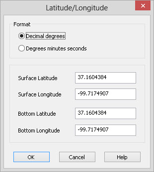
Format
Specify
the
format in which to view the latitude and longitude values.
Decimal
degrees: View
the latitude and longitude values in degrees with a decimal place.
Degrees minutes seconds: View the latitude and longitude values as degrees, minutes and seconds with a decimal place on the seconds component.
Locations
Surface Latitude: The latitude of the top hole location of the well.
Surface Longitude: The longitude of the top hole location of the well.
Bottom Latitude: The latitude of the bottom hole location of the well.
Bottom Longitude: The longitude of the bottom hole location of the well.
Operations
 OK: Apply
any changes you have made in the dialog. This will
convert
the latitudes and longitudes into the coordinate system of the project
and update the locations in the main well
page.
You need to have a coordinate system defined for your project in order
to perform the conversions. Coordinate systems can be set in
the Project
Properties
application.
OK: Apply
any changes you have made in the dialog. This will
convert
the latitudes and longitudes into the coordinate system of the project
and update the locations in the main well
page.
You need to have a coordinate system defined for your project in order
to perform the conversions. Coordinate systems can be set in
the Project
Properties
application.
 Cancel: Exit
this dialog without making any changes.
Cancel: Exit
this dialog without making any changes.
Specifying degrees
You can type in values in either decimal degrees or degrees minutes and
seconds. You do not need to set the format
in order to type in a value. The application will attempt to
automatically decipher any values you have typed in.
Directions
can be specified with either an optional minus (-) sign for S and W, or
with the
indicators N, S, E and W. Some examples of valid degrees specifications
are:
- 45.324
- -45.324
- 45.324 N
- 111 19 26.4
- -111 19 26.4
- 111 19 26.4 W
Also See
— MORE INFORMATION

|
Copyright © 2020 | SeisWare International Inc. | All rights reserved |