Specify Geometry
Use the Specify Geometry page to specify the location information for the traces within your data file. This is not necessary if you have already defined the geometry in with keywords.
You need to specify three corner points to
define
the geometry. You will normally obtain these corner points
from
your data vendor. Once defined the data loader will calculate
locations for each trace in the file and store the results in the
header of the output SEG-Y file. The corner points do not
need to
be defined in any particular order.
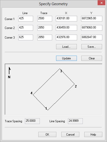
 Load: Load in a text file that contains the
corner geometry information for the 3D.
Load: Load in a text file that contains the
corner geometry information for the 3D. Save: Saves the current geometry
information
entered about the 3D to a text file that can be used later.
Save: Saves the current geometry
information
entered about the 3D to a text file that can be used later.  Update: After
specifying all the corner information update the geometry dialog
to verify that the information you have supplied is correct.
A
small map of the survey will draw allowing you to QC your inputs.
Update: After
specifying all the corner information update the geometry dialog
to verify that the information you have supplied is correct.
A
small map of the survey will draw allowing you to QC your inputs.Trace Spacing: This is the distance between each trace in the inline direction. Use this value to verify that the coordinates you have entered are correct.
Line Spacing: This is the distance between each trace in the crossline direction. Use this value to verify that the coordinates you have entered are correct.
Also See
— MORE INFORMATION

|
Copyright © 2020 | SeisWare International Inc. | All rights reserved |