AccuLink
AccuLink can be used to import general well information and tops
from AccuMap ® .
You can import wells that do not exist or update wells that already
exist in the project, depending on the configuration set for import.
 How do I import wells using AccuLink?
-
Select your Source, Domain and Coordinate System. Note:Ensure the Domain and Coordinate System are correct or not information will be imported.
-
To update existing wells, select Use wells in project. To update and add new wells select Use wells in region. To fill in the Region Definition, either manually enter in the coordinates or use the left click option to drag out an area on your map.
-
Under General Well Information select Use all GWI in AccuMap. This will update all information for your wells.
-
Under the Formation Options use Select AccuMap Formations if you are bringing in new formations, or Use all formations in projectt if just an update is needed. Note:If you are bringing in user tops make sure to turn off Use Age Equivalence in order to see them in the available formations list. Do not selectUse all formations in AccuMap.
-
If bringing in new formations, move the formations of interest from the Available formations section to the Formations to use section.
-
Leave Use formation name as isselected. This will bring in the formations as they appear in the Formations Option.
-
Click
 .
. -
Select Yes to override the warning that appears. AccuLink will now attempt to bring in your well information. Note: Depending on area extents and network speed this process can take between 1 - 15 minutes, so please be patient.
General Information
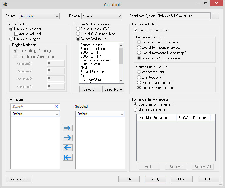
General
Source:Select the source name to use for tops imported by AccuLink. This will ensure that you do not overwrite existing tops that you may have entered or imported. By default, the name AccuLink is set. If you are importing user tops, you can select a name from the drop down, or type a new Source into the field.
Domain: Specify the AccuMap domain for the source of the data. This is usually a Canadian province or US state. If your project crosses a border, you will need to run the import process for each of the domains that the project lies in. Note: In order to use Domains not listed you must have purchased them through AccuMap.
Coordinate System:Specify the coordinate system appropriate for the data. If a coordinate system for the project has been set this will automatically fill in. If it has not filled in you will need to ensure you select the same coordinate system as your SEG-Y files. AccuMap stores all well positions in latitudes and longitudes. You must specify the correct coordinate system to project the well correctly into your project as wells are drawn using northings and eastings.
Wells To Use
Use Wells In
Project: Select this option
to import information for only those wells that already exist in a
project. Use the "Active
wells only" option to import information for only the wells in
the project that are currently active.
Use Wells In Region:Select this option to import all the
wells that exist within a region that is determined either using
latitude/longitude or XY coordinates for your project. This will
update any existing wells in
that region and will add new wells if they do not already exist. In order to select your
coordinates from your map you must be using the XY coordinates.
Region Definition
Use Northings / Eastings: Select this to specify the region using XYs. You can either type in the Minimum and Maximum X and Y values into the fields provided, or you may select a rectangle from the map to specify the region.
Use
Latitudes/Longitudes: Select
this to specify the region using latitude and longitudes for a region.
You must type in the Maximum and Minimum Latitude and Longitudes.
General Well Information
Do Not Use Any GWI: This option should be selected if you do not wish to import any general well information. This is used when importing tops only.
Use All GWI in AccuMap: Import all available general well information from AccuMap. This will update all of the fields found on the Well tab of Well Properties.
Select GWI to Use:
This option will show all items that AccuMap stores that you are
able to import. Select one or, using the Ctrl key, a group of items by for import.
Note:When importing general well
information, ALL wells that are imported will have the information
overwritten by the data imported.
Formations Options
Use Age Equivalence: Turn this on when you do not wish to see User Tops or Top Multiples. This would show and import only the formation 2WSPK instead of 2WSPK A, 2WSPK B, 2WSPK C etc. as they are listed in AccuMap.Note: If multiple values exist, the depth value of last formation in the grouping is the one that will be imported.
Formations To Use
Do Not Use Any Formations: Select this if you do not wish to import any well tops. Select when importing general well information only.
Use All Formations In Project:Import only formations that are currently in the project.
Use All Formations In AccuMap: Import all the tops that AccuMap has available. Note:Use extreme caution when selecting this option because all 40000 AccuMap formations will be imported which may have serious impacts on the performance of your project.
Select AccuMap Formations: Select this if you would like to import a portion of the well tops available in AccuMap. With this checked, you can then select one or more formations you would like to import into your project. Note: Ensure Use Age Equivalence is unchecked if you wish to see your User Formations.
Note:If formations are being used, the project may have top names that do not match those in AccuMap (or vice versa). To correct this use theFormation Name Mapping feature described below.
Source Priority To Use
Vendor Tops Only: Import the vendor tops from AccuMap.
User Tops Only:Import the tops created by a user in AccuMap.
Vendor Over User Tops: This will import both vendor tops and tops created by a user that are in AccuMap. However, the user top will not be imported if a vendor top exists.
User Over Vendor Tops: This will import both vendor tops and tops created by a user that are in AccuMap. However, the vendor top will not be imported if a user top exists.
Formations
This option is only available when the Select AccuMap Formations in
the Formations Options section is selected.
Formations to Use: The selected AccuMap formations that will be brought into the project if they exist.
Formation Name Mapping
When well tops are imported from AccuMap by default, they will just be imported with the AccuMap formation name. This can be overridden by using formation name mapping. If set, tops are then renamed using the formation name map first and then using default names. If you select "Use all formation in project" and you have a top called "Wabamun" in your project,but called "Wab" in AccuMap the formation map can rename "Wab" to "Wabamun" which will then correctly import.
Use Formation Names As Is:Select this option to use the AccuMap formation names without modification.
Map Formation Names:This option will enable the formation mappings.
You should then add one or more formation mappings by clicking  . If formation mappings
are used, the imported AccuMap formations are renamed to the
corresponding formation name as specified.
. If formation mappings
are used, the imported AccuMap formations are renamed to the
corresponding formation name as specified.
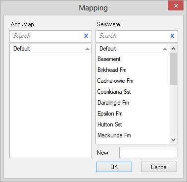
Add: Will open the
dialog below, then select one or more AccuMap formation names to be
mapped. Then select a corresponding project formation name, or enter a
new name. During import, any formation that matches the AccuMap
formation(s) will be renamed as specified.
 Remove: Select a
formation mapping first, then click to eliminate that formation
mapping.
Remove: Select a
formation mapping first, then click to eliminate that formation
mapping.
 Remove All: Remove
All will remove all current formation mappings.
Remove All: Remove
All will remove all current formation mappings.
Diagnostics
 Diagnostics:
Check the connection between SeisWare and AccuMap to help diagnose
connection issues.
Diagnostics:
Check the connection between SeisWare and AccuMap to help diagnose
connection issues.
Also See
— MORE INFORMATION

|
Copyright © 2020 | SeisWare International Inc. | All rights reserved |