Import Tools: Point Sets
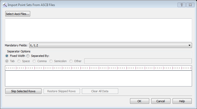
The Import Point Sets from ASCII File dialog box is used to import point sets from columnar ASCII files. You can open this dialog box by selecting Point Sets from the Import menu in the File menu in the 3D View, Map View, and Section View windows. When you are importing a point set file with more than one million points, select Point Sets (XYZ ASCII Data).
Import Point Sets
You can import point sets from any columnar ASCII file. The file must have a columns containing X, Y, and Z values. Optionally you can label a Surface Name column.
- Click
 and select one or multiple columnar ASCII file containing point sets. Note: When you are importing multiple files the files must have the same format.
 - Specify the Separator Options. The contents of the file will appear in the field at the bottom of the dialog box, and each field will appear in its own column when these have been correctly specified. When you are loading a file with Fixed Width columns, click on the ruler above the data to create a column separator. Click again to remove it.
- Click the button at the top of each column and select the appropriate field name. Data from columns that aren't labeled will not be imported.
- Select any rows, specifically header rows, that should not be included in the operation, and then click
 .
. - Click
 . This will open the Define Point Set Depth Type dialog box.
 -
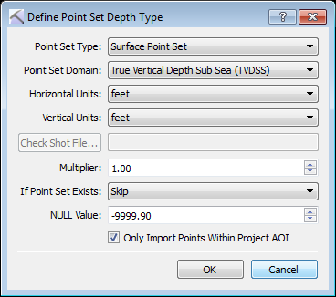 Make selections for the following. Note: Some options will only be available if you define a Surface column.
- Point Set: Select the point set type. Choose Surface Point Set or Fault Point Set.
- Point Set Domain: Select the domain for the Z values in the file. Choose TVDSS or Time.
- Horizontal Units: Select the units for the X and Y values in the file. Choose Meters or Feet.
- Vertical Units: Select the units for the Z values in the file. When working in the depth domain choose Meters or Feet. When working in the time domain choose sec or msec.
 Check Shot File: Select a check shot file, used to convert point sets into the depth domain.
- Multiplier: Enter a multiplier for the Z values in the file. This can be used to convert positive depth values into negative depth values.
- If Point Set Exists: Specify the behavior if the point set exists in the project. Choose from Skip, Replace, or Append.
- NULL Value: Define a null value when importing .xyz grid data.
- Only Import Point Within Project AOI: Limit the points that are imported using the project limits.
- Click . A final message will appear indicating that the files have been imported.
— MORE INFORMATION

|
Copyright © 2020 | SeisWare International Inc. | All rights reserved |