Grid Tools: Conformable Gridding
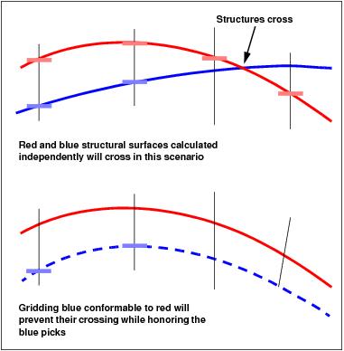 When you generate a surface from a limited number of picks, you may end up with a surface that honors the data, but doesn't honor the known geology. The surface created from sparse data may incorrectly cross a surface located above or below it. Conformable gridding allows you to map a surface, honoring the known data points, while taking into account the shape of a reference surface with more control, for example a seismic horizon.
In the example shown, when you choose to grid the blue surface conformable to the red surface, the difference in elevation of the blue picks and the back-interpolated elevation values of the red surface at the XY locations of the blue picks is calculated.
A residual grid is created, based on the difference values, which is subtracted from the red grid. The result is a grid that honors the blue picks where they exist, but follows the shape of the red grid when blue picks don't exist.
You can turn on conformable gridding from the Framework tab in the Surface Display and Data dialog box opened from the 3D View window.
— MORE INFORMATION

|
Copyright © 2020 | SeisWare International Inc. | All rights reserved |