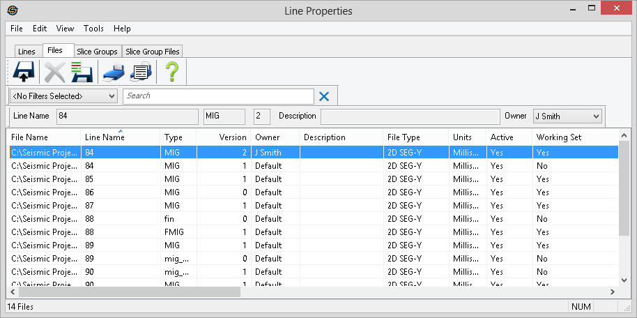
Line Properties: Files Tab
When you open the Line Properties, there are four tabs at the
top. The File tab lists information about all lines and their
versions in the project. SEG-P, and Slice files are also visible in
this
view.
General Information
You can sort any column by clicking on the column heading, and re-order columns by dragging the column heading to a new position. You can access the additional tools using the top menus and toolbars, or right clicking in the table area. Some tools are specific to the line or lines that are currently selected in the table.
Double click on any line to open the 2D Detailed Properties or 3D Detailed Properties dialog to see more information about each line.
Columns
File Name:The actual name of the file on disk.
Line Name: The internal line name for the file.
Type:The type identifier for a file. The type helps to uniquely identify a file.
Version: The version number of the file. The version number helps to uniquely identify a file.
Owner: The owner of the file.
Description: An optional description for the file.
File Type:Specifies what kind of file it is. Possible values are 2D SEG-Y, 3D SEG-Y, SEG-P, and Slice.
Units: Specifies the units for the vertical domain of the file. This will be either Milliseconds, Meters, Feet or Hertz.
Active: Specifies whether the file is active. Only active files appear on the map.
Working Set:Indicates whether the file is a member of the working set. Working set files are the currently active version for a given line. This will be the default version that appears on the map, or in dialogs.
Traces: Indicates the total number of traces in a file.
Start: Indicates the starting time of the file. The starting time does not include any bulk shift applied to the data.
End: Indicates the ending time of the file. The ending time does not include any bulk shift applied to the data.
Shift: Indicates the bulk shift applied to a file.
Peak: The peak amplitude value of the file.
Average: The average amplitude value of the file.
RMS: The RMS amplitude value of the file.
Phase:If a file was phase rotated in SeisWare, the value will display here. This value is cumulative if multiple rotations are performed.
Gain:If a file had a gain applied in SeisWare, the value is stored in this field.
Gain Exponent:If a file had a gain exponent applied in SeisWare, the value is stored here.
First Shot:The lowest shotpoint value in the file. Only meaningful for 2D lines.
Last Shot: The highest shotpoint value in the file. Only meaningful for 2D lines.
First CDP: The lowest CDP value in the file. Only meaningful for 2D lines.
Last CDP:The highest CDP value in the file. Only meaningful for 2D lines.
Polarity:Specifies the polarity of the file. This will be either Normal or Reverse.
Min X: The X coordinate of the left-most trace in the file.
Min Y: The Y coordinate of the bottom-most trace in the file.
Max X:The X coordinate of the right-most trace in the file.
Max Y: The Y coordinate of the top-most trace in the file.
Length:The total distance of the line measured from trace to trace. This distance will be in map units which are normally meters. This value only applies to 2D lines.
Also See
— MORE INFORMATION

|
Copyright © 2020 | SeisWare International Inc. | All rights reserved |