Import Tools: Grid Files
Use the Import Grid File dialog box to import grids into your project. You can open this dialog box from the from the File menu in the 3D View, Map View, and Section View windows.
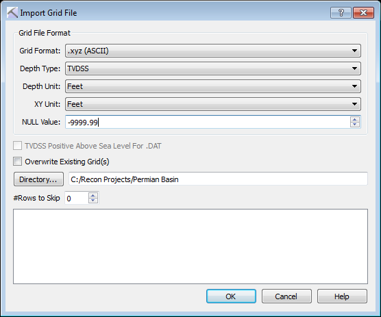
To import grid files, specify a directory and then select the files you want to import from the data field at the bottom of the dialog box.
Grid File Format Options
Use these options to describe the grid file.
Grid Format: Select the correct format for the grid file to import. Note: The grid files must have the indicated extension, and the data within the file must be formatted correctly as there is no way to customize the import operation.
.grid: Import a .grid file. Files imported from outside of the project will be placed in the Grids folder within the project folder.
.DAT: Import a Landmark ZMAP ,DAT grid file.
.xyz: Import a columnar ASCII grid file. Columns must be ordered X, Y, Z. When you select this option you will be able to specify a Null Value, and indicate how many rows should be ignored at the begin of the file.
Depth Type: Select the depth reference. Choose from TVD or TVDSS.
Depth Unit: Select the depth units used in the file. Choose from Meters or Feet.
XY Unit: Select the map units used in the file. Choose from Meters or Feet.
NULL Value: Define a null value when importing .xyz grid data.
Additional Options
TVDSS Positive Above Sea Level For .DAT: Turn this on when required if you are importing .DAT files.
Overwrite Existing Grid(s): When this is turned on, existing grids will be replaced if they have the same name as the grids being imported.
 Directory: Select the directory that contains the files. Note: You can't select individual files. A list of files within the selected directory will appear in the data field at the bottom of the dialog box.
# Rows to Skip: Indicate how may rows to skip when importing .xyz grid data.
— MORE INFORMATION

|
Copyright © 2020 | SeisWare International Inc. | All rights reserved |